弁山半島海岸道路
弁山半島海岸道路は、新万金防潮堤を渡り、全北扶安郡弁山面大港里の国道30号線海岸道路と合流する地点から始まる。曲がりくねった海岸線に沿って採石江、格浦港、熊沼港まで走る全長35.4kmの区間で、魅力的なドライブコースである。広がる青い海だけでなく、静かな海岸の村、数万年の波に削られて独特な形を成した海岸崖、生物の宝庫である干潟、神秘的な弁山半島国立公園外弁山の主要な名所、大小さまざまな弁山半島の海辺にも出会える。
この場所はどうでしたか?
このコースは2日間の旅程サンプルです。そのまま保存するか、AI日程に拡張できます。

1日目
Gosapo Beach 〉


Gosapo Beach is located in Unsan-ri, Byeonsan-myeon, Buan-gun, featuring a white sandy beach about 2 km long and a wide, long pine forest about 300 m planted for wind protection, creating a magnificent view. It boasts the largest scale among the area's beaches. The water is clearer and cleaner than other beaches on the West Sea, and the sand is known to be fine and soft. The water temperature is moderate, making it a popular spot for family tourists who enjoy sea bathing in summer. The pine forest is suitable for resting in the shade or camping after enjoying the sea. It is also famous for its beautiful sunset, typical of West Sea beaches. Around the 15th day or the end of each lunar month, a sea path about 2 km long, called the modern-day miracle of Moses, opens from the beach to here. At this time, visitors can walk to the island and enjoy catching clams, octopus, sea cucumbers, and more. In front of the beach, there is a small island called Haseom, named for its resemblance to a shrimp. It is owned by the Wonbulgyo Foundation, and the general public must obtain prior permission to enter the island, but mudflat experiences to the island are allowed when the sea path opens.
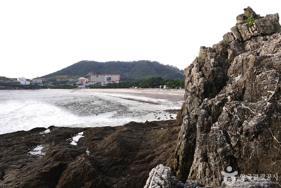
Chaeseokgang 〉


This sedimentary rock, formed about 70 million years ago from the Cretaceous period of the Mesozoic era under marine erosion, consists of the Gyeokpori Formation including conglomerate over conglomerate, alternating layers of conglomerate and sandstone, sandstone and mudstone, shale, and volcanic ash. This sedimentary environment suggests this area was once a deep lake where volcanic ejecta settled on the lakebed. Faults, folds, intrusion structures, and wave-cut platforms are also easily observed in these cliffs, making it excellent for studying topography and geology. Wave erosion has created sea cliffs, flat wave-cut platforms, and sea caves. The bottom of Chaeseokgang features potholes formed through crust and wave action, along with tidal pools formed by seawater trapped during high tide. ◎ Travel info to experience the charm of cold currents - The drama begins where Ban Ji-eum, carrying memories of a past life like waves, slowly walks at the towering cliffs and sea caves. The sedimentary rock formed since about 70 million years ago during the Cretaceous period seems to reflect the long years she has endured.
2日目
Sangnok Beach 〉


Sangnok Beach is located in Unpo Village, Docheong-ri, Byeonsan-myeon, Buan-gun. Since its opening in 1988, it was initially only available to public officials and their families but is now open to the general public. Behind the sandy beach is a windbreak forest made of pine trees and scattered strange rock formations. The water is shallow, and the sand is clean. In a 1999 water quality test, it received first-grade status. Around the beach, there are well-equipped convenience facilities such as restaurants, a swimming pool, volleyball court, shower room, cooking area, and camping site. Additionally, a natural camping site in the pleasant pine forest operates for a fee. It is located in section 4 of the West Sea Trail 46 course and Buan Byeonsan Masil Trail Coastal 8 course, covering 'Gyeokpo Port~Gung Port~Sol Island.' Starting from Gyeokpo Port, passing the Jeolla Left Naval Command set, Gung Port, and reaching Nonghyup Byeonsan Training Center, Sangnok Beach is visible. The beach is about the midpoint of the approximately 5 km Masil Trail, making it an ideal spot for round-trip trekking toward Gyeokpo Port or Sol Island.
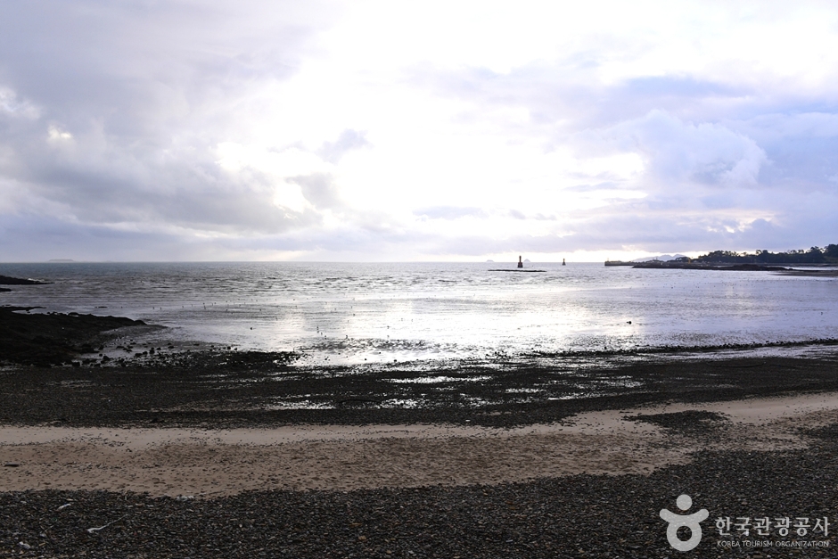
Gomso Port 〉


Gomso Port is located around Jinseo-ri, Jinseo-myeon, Buan-gun. It is the second largest port after Gunsan Port. When Julpo Port was closed due to sedimentation, in 1938, a seawall was built linking Gom Island in front of Jinseo-ri with Beom Island and Yeondong to the east, and Ggachi Island and Jakdo-ri to the west, creating this harbor. It is a forward base for West Sea fisheries. The name Gomso comes from two islands shaped like bears and the deep pools in front of these islands, with a proverb saying "Gomso is deep like a bear's pond." Ferries operate to Wido. Gomso Port is active, with about 130 fishing vessels entering daily. Surrounding Gomso Port are large-scale salt fields, the largest salted seafood market in Korea called Gomso Jeotgal Market, a seafood market, and a dried seafood market, attracting many tourists. Salt fields literally mean 'fields where salt is made.' Salt is made by drying seawater with wind and sunlight in salt fields, called natural solar salt, distinct from factory-made chemical salt. Salt production involves reservoirs, evaporation ponds, and crystallization ponds. Seawater is stored in reservoirs during high tide, then sent to evaporation ponds through long channels, containing 5% salinity. After 7–8 days of evaporation there, water moves to crystallization ponds (salt fields with jar-piece tiles). Mixing about 30kg of existing salt with evaporated water creates foam; bubbles attach to evaporated alkali and sink. This brine has about 25% salinity. After 2–3 days drying by wind and sun in crystallization ponds, salt forms, which is raked and stored. The natural solar salt made here creates the famous Gomso salted seafood, widely acclaimed nationwide with many visitors eager to purchase it.
このコースなら、ここで1泊すると移動が楽です
コース周辺で移動しやすく、満足度の高い宿を選びました


この都市の他のおすすめ日程
旅行レビュー
旅行のコツをシェアして、SNSも一緒にアピールしましょう。
会員登録して自分のチャンネルも一緒に紹介してもらう
(会員になると、マイページで設定した Instagram・YouTube・ブログのリンクが、あなたのコメントと一緒に表示されます。)
- ✔ あなたが書いたすべてのコメントに、SNSリンクが表示されます。
- ✔ コメントがベストに選ばれると、SNSリンクとともにホームページ上部にも掲載されます。
“「弘大近くに滞在して、夜のカフェ巡りをしました。街の夜景も雰囲気も最高でした。」”
ゲストとして投稿したコメントには、SNSリンクやプロフィールカードは表示されません。
旅行のひとことコメントを書く
この場所についてのちょっとしたコツや感想をシェアしてください。
ゲストとして、気軽にひとことコメントを残すこともできます。
ドラッグ&ドロップ、またはクリックして画像を追加(最大6枚)
まだレビューがありません。最初の感想を投稿してみましょう!