海苍路)
海苍路是从釜山五六岛开始的全长750公里的韩国最长徒步旅行路线。这里介绍的是韩国最北端高城和束草区间的海苍路。海苍路48、49路线包括位于花津浦的“金日成别墅”和可以欣赏美丽日出的“白岛海上展望台”。这条路线上的别墅曾是金日成和李承晚休息之地,体现了韩国分裂的历史。海苍路47路线经过形似人侧脸的“书郎岩”,通往仅在江原北部可见的独特传统结构民居“王谷村”。海苍路46路线可以坐在被波浪拍打的“能波台”岩石上沉思,也可以步行至长项港。海苍路45路线为束草单一路线,包含蜷伏的熊岩、曾是新罗花郎英朗停留的“英朗湖”、跨越约50米长云桥可直面大海的“英金亭”,以及夜景闪耀的“清草湖”。
这个地方怎么样?
这条路线是 4 天行程示例。你可以直接保存,或扩展为 AI 行程。

第1天
백섬해상전망대 〉
거진항 어촌관광체험마을 조성사업의 일환으로 2019년 3월부터 2020년 10월에 걸쳐 조성하였으며, 2020년 10월 30일 관광객에게 개방되었다. 총길이 137m, 높이 4~25m 규모로 해안도로와 백섬(백암도)을 연결하여, 아름다운 동해바다 위를 걸으며 북쪽으로는 해금강과 금구도를 조망할 수 있으며, 남쪽으로는 거진항구와 거진11리 해변이 펼쳐져 장관을 이룬다. 높이 25m의 전망대 일부에는 투명한 강화유리 바닥이 조성되어있다. 거진 뒷장에 위치한 백섬(백암도)과 해안도로를 연결하는 해상데크로 길이 137m, 폭 2.5m, 높이 4~25m 규모이다. 해상전망대에 오르면 동해바다와 해금강, 금구도, 거진항구의 아름다운 경치를 관람할 수 있다.
Goseong Wangkok Village 〉
★4.1(1.3k)


Wangkok Village is located about 1.5 km inland from the coast and is surrounded by five hills shaped like peaks about 200m above sea level and the lagoon Songjiho (circumference 4km, area 200,000 pyeong), forming a basin in the shape of a 'gol' isolated from the outside. To the east of the village is Golmusang, to the southeast Songjiho, to the south Hogunsan and Jegoksan, to the west Jinbangsan, and to the north Oeumsan. Oeumsan, located north of the village, extends southwest through the village along the Wanggokcheon stream, forming a settlement with deep longitudinal shape. Houses are naturally arranged along the village road that follows the stream in the village center, characterized by relatively wide vegetable gardens between houses without separate fences, separating the houses by the garden boundaries. The house structure of Wangkok Village includes an anbang (main room), dojangg (storage room), sarangbang (men’s quarters), maru (wooden floor room), and kitchen all in one building, with the kitchen attached to a livestock pen in a combined house structure. The front yard, directly connected to the village road, serves as a communal work space open to outsiders, while the backyard, surrounded by relatively high walls, is a private space for women and not open to others. Only the roof of the backyard is visible, reflecting a design considerate of women's activity space. The traditional houses of Wangkok Village, full of history and tradition, also offer lodging experiences. One can escape modern urban life and spend quiet, relaxed time in a place where time seems to have stopped, living just as 200 years ago.
第2天
Songjiho Coastal Seonnang Rock 〉
★4.4(316)


Seonnang Rock is a rocky coast developed in the granite area south of Songjiho Beach, where weathering landforms of granite and wave erosion combine to create a very unique geological landscape. In particular, thick quartz veins intrude between granite layers, forming a distinctive appearance. The name Seonnang Rock comes from the Seonnangdang (Seonghwangdang) shrine of Oho-ri village located there. Seonnangdang is a traditional Korean shrine area dedicated to the village guardian deity, Seonnangshin (Seonghwangsin), and is a place where it is taboo to damage or remove objects freely. Additionally, Seonnang Rock changes shape depending on the viewing direction (east, west, south, north), and is nicknamed Snoopy Rock because it resembles Snoopy. Especially remarkable is a small pine tree growing atop the rock. Next to the fan-shaped rock, there is another curious rock: a cube-shaped rock with a hole in the center and a small pine tree growing between its cracks.
Neungpadae 〉
★4.2(911)


Neungpadae (凌波臺) is a large-scale tafoni colony developed on the rocky coast forming a land-tied island called Yukgyedo (陸繫島). The name Neungpadae, meaning “the rock island surpassing the waves,” was given because of the sight of waves crashing against the rocks. Yukgyedo refers to an island connected to the mainland by accumulated sand dunes, and tafoni are groups of holes clustered like a honeycomb on the rock surface (cliffs). Originally, Neungpadae existed as a granite bedrock island (rock reef) exposed in front of Munam Coast but connected to land by sand deposited behind the island by Munam Stream as wave action decreased. However, now Munam 2-ri harbor has been built along the southern boundary of Neungpadae, and settlements have arisen on the land-tied sandbar connecting the island and Munam Coast, so the original form of Yukgyedo is hardly observable. (Source: Gangwon Peace Region National Geopark website)
第3天
장사항 〉
장사항은 속초시 장사동 일원에 위치한 소규모 어항으로서 방파제 90m, 방사제 144m, 물양장 130m 및 어선 30여척을 보유한 전형적인 어촌으로, 주위에 횟집 및 활어판매장이 50여곳이 있어 싱싱한 활어회를 즐기기에 안성맞춤이며 특히 가까운 곳에 배낚시 어장이 형성되어 바다낚시를 즐길 수 있는 최적지이다. 이곳에서는 매년 여름 피서철 동안 오징어를 맨손으로 잡는 축제가 열려 시원한 즐거움을 더해준다.
英朗湖 〉
★4.6(90)


英朗湖是由海岸沙丘发育形成的自然石湖,周长7.8公里,面积约1.2平方公里,水深超过8米。由长川川流入,通过英朗桥下的水道与东海相连。湖泊被束草市长沙洞、英朗洞、东明洞和金湖洞环绕,湖边设有适合散步的步道。步道沿线风景优美,湖水清澈平静,樱花、映山红和芦苇交织成诗意画面。根据《三国遗事》,英朗湖得名于新罗花郎“英朗”。传说英朗在金刚山修炼后途经此湖,被其秀丽景色吸引,忘记了武术大会,长时间停留于此。古籍中亦有记载,英朗湖以其卓越景致著称。特别是束草八景之一的범바위(虎岩),其形似静卧的老虎,充满神秘气息。聚集多块奇岩怪石的观音岩和普光寺也是不可错过的景点。湖西侧的湿地生态公园也值得一游。
第4天
灵琴亭 〉
★4.3(11.8k)
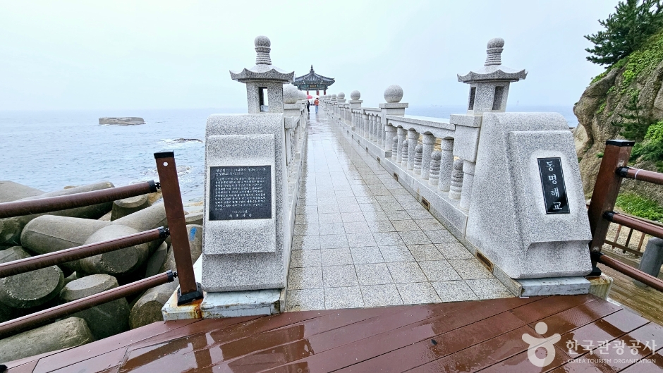


灵琴亭位于束草市东明洞束草灯塔下的海边,那里铺满了大而宽广的岩石。地名的由来是波浪撞击岩石时发出神秘的韵律声,这声音被认为像神圣的‘古琴’声,因此称为灵琴亭。该地距离市区较近,风景优美,四季都有束草市民在此避暑和钓鱼。现在束草市将灵琴亭一带开发为旅游景点,在南侧防波堤附近建有一座海上亭子。该亭子建在灵琴亭岩石上,可通过约50米的桥梁进入。海上亭子眺望大海,感觉与防波堤不同,别具一格,但亭子本身为混凝土结构,略显遗憾。通常称为日出亭,亭匾上书有“灵琴亭”字样。
清初湖 〉

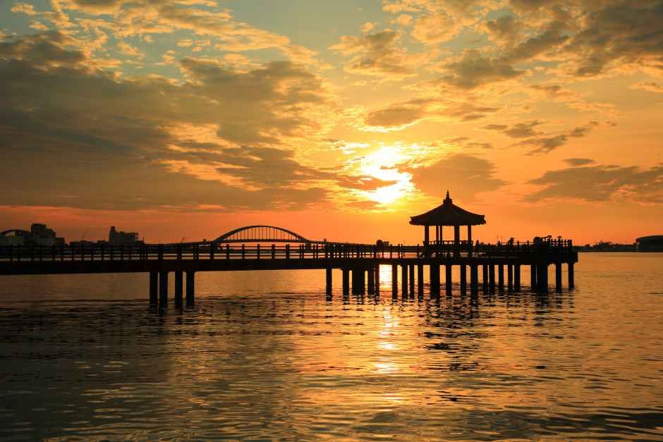

清初湖位于束草市中心,是一个自然石湖,周长5公里,面积1.3平方公里。清初川从太白山脉的微始岭附近流出,形成美丽的湖泊后流入邻近的东海。湖面上建有清初亭,可观赏雪岳山和东海的景色。清初亭位于长约75米的海上步行桥末端,仿佛置身湖中央。夜晚的清初亭灯光璀璨,是束草著名的夜景胜地。湖边有象征龙的青龙和黄龙雕塑,传说与湖中龙的故事有关。环湖步道配备夜间照明,设有多处长椅,适合休憩。清初湖周边还有石峰陶瓷美术馆和候鸟栖息地等景点。湖畔的清初湖公园曾于1999年举办江原国际旅游博览会,设有高73.4米的博览会塔观景台。


该城市的其他推荐行程
旅行评价
分享你的旅行小贴士,也让更多人看到你的社交账号。
注册成为会员,让更多人认识你的频道。
(成为会员后,在“我的页面”中设置 Instagram、YouTube、博客链接,我们会在你发表的每条评论旁一起展示。)
- ✔ 你发布的每一条评论旁都会显示你的社交账号链接。
- ✔ 如果你的评论被选为「最佳评论」,我们还会在首页顶部突出展示你的留言和社交账号。
““住在弘大附近,晚上去了一圈咖啡馆,城市夜景和氛围都太完美了。””
以访客身份发表的评论,不会显示任何社交账号链接或个人资料卡片
写下一条旅行短评
分享一条关于这个地点的小贴士吧。
或者以访客身份快速留下一个评论。
拖拽或点击添加图片(最多6张)
还没有任何评论,快来写下你的第一条感受吧!