One Day Full Circle Tour of Ulleungdo
This is a course where you use a tourist taxi or bus to go around Ulleungdo Island in one day. However, since the island’s circular road is not perfectly connected, there is the inconvenience of having to backtrack. If you want to go all the way around the island, you need to cover the disconnected sections on foot or by trekking. Tours using vehicles usually take about 5 hours. It is good to include the Haengnam Coastal Walk, which starts at Dodong Port, to make a one-day itinerary.
How was this place?
This course is a sample one-day itinerary. Save it as-is or expand it into an AI itinerary.

Dodong Port 〉


Dodong Port is a fishing port on Ulleungdo located 188 km northeast of Pohang, operating routes that connect the mainland as well as Dokdo and Jukdo islands. The origin of the name Dodong comes from the term Dobangcheong, meaning 'a bustling place where many people gather.' In 1882, when the Ulleungdo Development Decree was issued with tax exemptions for settlers, more people began entering Ulleung County. At that time, Japanese people were already living there, forming a sizable town area called Dobangcheong. Later, when naming the area, the character 'Do' from Dobangcheong was used, resulting in the name Dodong. The port facilities include loading facilities such as quay walls and freight yards, and outer structures such as breakwaters and jetties. Dodong Port serves as the administrative and logistics center of the Ulleung area, with high-speed ferries operating from Pohang in Gyeongsangbuk-do and Mukho in Donghae-si, Gangwon-do, serving as the gateway to the Ulleung region.
Sajabawi 〉


Sajabawi is located on the coast of Namyang-ri and can be seen by passing the Gadu Peak lighthouse and turning around the corner. It is called Sajabawi because the shape of the rock resembles a lion. This area is known for its beautiful sunset views along with Sajabawi, making it a must-visit spot for tourists coming to Ulleungdo. The legend of the rock is related to Waehae-wang, the last king of Usan-guk. Isabu, ordered by King Jijeung to conquer Usan-guk and make it pay tribute, carefully planned a strategy considering Usan-guk’s geographical location as a natural fortress surrounded by cliffs and the fierce temperament of its people. Isabu then made a wooden lion, an animal feared by Usan-guk people, and placed it on a ship. Days later in battle, despite the strong resistance of Usan-guk people, when Isabu raised the snarling lion at the bow of his ship and shouted for surrender, the fierce Usan-guk people, confronted with the monster they had never seen before, ultimately surrendered. It is said that Isabu floated the wooden lion on the water to soothe the spirit of Waehae-wang, who died in the fight because of the wooden lion, and Sajabawi was formed at that spot.
태하 향목 관광모노레일 〉
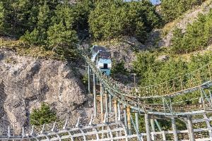
울릉도의 비경을 한 눈에 감상할 수 있는 관광 모노레일은 태하향목의 정상을 편안하게 감상할 수 있다. 관광모노레일 모노레일 재원은 총연장 304m의 레일에 20인승 카2대가 동시 운행하며 분당 50m의 속도로 산정까지는 약 6분 정도가 소요되고 최대 등판각도가 39도나 되지만 언제나 자동으로 수평을 유지하여 주기 때문에 안심하고 이용할 수 있다.
Elephant Rock 〉


It is a sea cave rock called 'Gongam,' meaning hole rock. It is also known as 'Elephant Rock' because it looks like an elephant dipping its trunk into the water and drinking. Elephant Rock, along with Samseonam and Gwaneumdo, is counted among the three major scenic sea views. The 10m natural cave allows small vessels to pass through and is highly popular as a top spot for skin diving.
Nari Basin 〉

Nari Basin is a caldera crater formed by the collapse of a volcanic crater following the eruption of highly viscous trachyte, andesite, and tuff during the late Tertiary period of the Cenozoic era. In the past, people had no livestock and ate the roots of the island lily, which gave rise to the place name Nari, and thus it was called Nari Basin. Its size is about 1.5 km in east-west width, 2 km in north-south length, and the area is 1.5 to 2.0 km². The basin is surrounded like a folding screen by mountains about 500m in elevation, with the highest peak, Seonginbong (984m), located to the south, and inside the basin is the conical central crater, Albong (611m). Nari Basin’s landform was created by the collapse of a crater north of Seonginbong during a volcanic eruption, covering an area roughly equivalent to 28 soccer fields. Due to its unique volcanic terrain, it is registered as a national geosite park, and walking trails and trekking courses have been established around Nari Basin. The most recommended course is the trail around Albong (538m) and Gitdaebong (579m). Given the island’s characteristics, there are Ulleung daisies and plants unique to Ulleungdo, allowing visitors to enjoy a forest landscape unlike anywhere on the mainland.
Seokpo Sunrise and Sunset Observatory 〉


The Seokpo Sunrise and Sunset Observatory was established in 1905 when the Japanese army set up a watchtower during the Russo-Japanese War, installing one barrack building, a wireless telegraph office, a lighthouse, a well site, and an underground shelter (cave). After the war, fearing Russian retaliation, the Japanese army stationed a battalion in Seokpo village and maintained the watchtower until 1945. During World War II, a cannon was transported by ship and moved by manpower from the harbor to this location with the help of village residents, but after liberation, the cannon disappeared and villagers dismantled bricks from the barracks to build silkworm houses, leaving only the building foundation as a trace. The observatory is located where the East Sea between Ulleungdo and the Korean Peninsula can be viewed, equipped with a two-story octagonal observatory, deck, and telescopes. From the octagonal observatory, the natural landscapes of Gongam (Elephant Rock), one of Ulleungdo’s three great scenic spots, Gwaneumdo, Samseonam, as well as Jukdo and the coastal cliffs of Buk-myeon, stretch out in full view. Below the observatory is the Seokpo resting area, and there is a Seokpo Old Road trekking course from Seokpo Observatory to Naesujeon Sunrise Observatory.
행남 해안산책로 〉
도동부두 좌해안을 따라 개설된 산책로가 절경이다. 자연동굴과 골짜기를 연결하는 교량사이로 펼쳐지는 해안비경을 감상할 수 있다. 해안산책로는 행남이라는 마을과 이어진다. 이 마을 어귀에 큰 살구나무 한 그루가 있었다고 해서 행남은 '살구남'으로도 불리고 있다. 마을에서 400m 정도의 거리에 있는 행남 등대는 먼 뱃길을 밝혀준다. 해송 사이로 이어지는 등대 오솔길은 가을철에 노란 털머위 꽃이 군락을 이루어 장관을 연출한다. 등대에서는 저동항 절경을 감상할 수 있다. (해안산책로 코스는 왕복 1시간 30분 정도 소요)
For this course, these stays make an easy overnight stop
Selected for easy access around the course and strong guest ratings


More recommended itineraries in this city
Travel Reviews
Share your travel tips & promote your social media.
Sign up to feature your channel.
(As a member, you can add your Instagram, YouTube, and blog links in My Page, and we’ll show them with every comment you write.)
- ✔ Your social media links appear with every comment you write.
- ✔ If your comment is chosen as a Best Comment, it’s also featured on our home page with your social media links.
““Stayed near Hongdae and did a night café tour. Perfect city views and vibes.””
Guest comments do not display social media links or profile cards.
Leave a traveler review
Share a short tip about this place.
Or leave a quick comment as a guest.
Drag & drop or click to add images (up to 6)
No reviews yet. Be the first to share your experience!